جبل ليووتوبي في حالة تأهب قصوى: الرماد البركاني يصل إلى ارتفاع 18 كيلومترًا
Alert Level for Mount Lewotobi Stays Elevated After Expelling 18 Kilometers of Ash
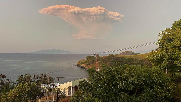
باندونغ، إندونيسيا اليوم – أبقت السلطات الإندونيسية على أعلى مستويات الإنذار لجبل ليووتوبي لاكي-لاكي، حيث يشير استمرار تدفق الحمم البركانية والغاز داخل البركان إلى احتمال وقوع ثورانات انفجارية جديدة. وكان البركان الواقع في جزيرة فلوريس بمقاطعة نوسا تينجارا الشرقية قد ثار بعد ظهر يوم الثلاثاء، مطلقًا عمودًا من الرماد بارتفاع يقدر بحوالي 1200 متر فوق قمته.
إقرأ أيضا : بعد إغلاق مؤقت: مطار كومودو يستأنف رحلاته عقب ثوران بركان ليووتوبي
وفي صباح يوم الاثنين، لوحظ ثوران عنيف مصحوب بعمود رماد كثيف ارتفع إلى حوالي 18 كيلومترًا فوق القمة. وفي المساء، وقع ثوران انفجاري آخر وصل فيه عمود الرماد إلى ارتفاع 13 كيلومترًا فوق القمة.
وصرح محمد وافيد، رئيس هيئة الجيولوجيا بوزارة الطاقة والثروة المعدنية، يوم الثلاثاء 8 يوليو 2025: “مع استمرار تدفق الحمم والغاز نحو السطح، قد يحدث تراكم جديد للضغط يؤدي إلى ثوران انفجاري أو تدفق للحمم البركانية أو تدفقات فتاتية بركانية”.
وسجلت الهيئة الجيولوجية نشاطًا زلزاليًا مستمرًا في جبل ليووتوبي لاكي-لاكي خلال الفترة من 7 إلى 8 يوليو 2025. وبناءً على البيانات المرئية، أظهر ثوران البركان طابعًا انفجاريًا مصحوبًا بضغط غاز قوي جدًا.
وأوضح وافيد أن الصوت المدوي المصاحب للثوران يشير إلى إطلاق مفاجئ لغاز عالي الضغط، بينما تشير التدفقات البركانية الفتاتية إلى انهيار عمود الثوران، مما ينتج عنه تدفقات شديدة الخطورة.
وأضاف وافيد أن “طبيعة الهزات الزلزالية المسجلة بعد الثوران تُظهر استمرار إطلاق الغازات البركانية (إزالة الغازات) في منطقة القمة، وأن تدفق الحمم لم يتوقف تمامًا”.
إقرأ أيضا : عودة الحياة الجوية لبالي: 18 رحلة تستأنف عملها بعد اضطراب بركان ليووتوبي
وأشار وافيد إلى أن بيانات تشوه الميلوميتر أظهرت أيضًا تضخمًا بطيئًا خلال الأسبوع الماضي، مما يدل على استمرار تراكم الضغط بسبب تدفق الحمم المستمر. في الوقت نفسه، تُظهر بيانات نظام تحديد المواقع العالمي تغيرات في المتجهات تميل إلى الإشارة إلى انكماش، مما يدل على انخفاض الضغط من داخل جسم البركان، لكن تراكم الضغط على الأعماق الضحلة لا يزال مرتفعًا.
وقال وافيد: “بناءً على التحليل المتكامل للبيانات المرئية والآلية، لا يزال نشاط جبل ليووتوبي لاكي-لاكي مرتفعًا، لذا يبقى مستوى نشاط البركان مصنفًا عند المستوى الرابع (أواس)، وهو أعلى مستوى تحذير”.
ومع بقاء مستوى الإنذار عند المستوى الرابع، طالبت هيئة الجيولوجيا بإخلاء جميع الأنشطة ضمن دائرة نصف قطرها 6 كيلومترات، وتوسيعها إلى 7 كيلومترات في القطاع الممتد من الجنوب الغربي إلى الشمال الشرقي من مركز الثوران. كما نُصح السكان المقيمون في المناطق المعرضة للكوارث بتوخي الحذر من احتمال حدوث تدفقات طينية بركانية (لاهار) إذا هطلت أمطار غزيرة.
واختتم قائلًا: “يجب توخي الحذر بشكل خاص في المناطق الواقعة على طول مجاري الأنهار التي تنبع من قمة جبل ليووتوبي لاكي-لاكي مثل دوليبالي، نوبو، هوكينغ جايا، ونورابيلين”، كما نصح بضرورة استخدام الأقنعة أو أغطية الفم والأنف لحماية الجهاز التنفسي من الرماد البركاني.
إقرأ أيضا : إلغاء الرحلات الجوية بين لابوان باجو وكوبانغ إثر ثوران بركان ليووتوبي
تابع الأخبار والمقالات الأخرى على قناة واتساب
نبيلة | إندونيسيا اليوم | تيمبو
Bandung, Indonesia Alyoum – There is still a supply of magma in the body of Mount Lewotobi Laki-laki, indicating the potential for another explosive eruption. The volcano, located in Flores, East Nusa Tenggara, Indonesia, erupted on Tuesday afternoon, spewing a column of ash about 1,200 meters above the mountaintop.
On Monday morning, the eruption accompanied by a thick ash column was observed soaring to approximately 18,000 meters above the peak or about 19,584 meters above sea level. In the evening, another explosive eruption occurred with the eruption column reaching 13,000 meters above the peak.
“With the ongoing supply of magma and the flow of gas/magma to the surface, the accumulation of pressure could occur again and trigger an explosive eruption, lava flow, or pyroclastic flow,” said Head of the Geological Agency at the Ministry of Energy and Mineral Resources (ESDM), Muhammad Wafid, on Tuesday, July 8, 2025.
The Geological Agency recorded seismic data of Mount Lewotobi Laki-laki six times on July 7-8, 2025. Based on visual data on July 7-8, 2025, the eruption of Mount Lewotobi demonstrated explosivity with very strong gas pressure.
Wafid explained that the booming sound indicates a sudden release of high-pressure gas. The presence of pyroclastic flows indicates the collapse of the eruption column, which produces very dangerous pyroclastic flows.
“The type of earthquake recorded after the eruption shows the ongoing release of volcanic gas (degassing) at the summit area and the supply of magma that has not completely stopped,” said Wafid.
Wafid stated that tiltmeter deformation data also indicates slow inflation in the past week, indicating the ongoing accumulation of pressure due to the ongoing magma supply. Meanwhile, GPS data shows changes in vectors and tends to still indicate deflation, showing a decrease in pressure from within the volcano’s body, but the accumulation of pressure at shallow depths remains high.
“Based on the visual and instrumental analysis, the activity of Mount Lewotobi Laki-laki is still high, so the level of activity of Mount Lewotobi Laki-laki is still categorized as Level IV (Awas),” said Wafid.
With the Level IV or Awas status, the Geological Agency requests the evacuation of activities within a radius of 6 kilometers and sectoral 7 kilometers in the Southwestern-Northeastern direction from the eruption center. Residents living in disaster-prone areas are advised to be wary of the potential for lahars if heavy rains occur.
“Especially in areas along river channels originating from the peak of Mount Lewotobi Laki-laki such as Dulipali, Nobo, Hokeng Jaya, and Nurabelen,” he added, also advising the use of masks or mouth and nose covers to protect the respiratory system.
Nabilah | Indonesia Alyoum | Tempo